Aerial view of the Estero Americano meeting the Pacific Ocean at sunset
Bodega Harbour Homeowners Association — February 2026

A Community in Alignment

A century in the making — every team’s hard work got us this far.
Our shared efforts will carry us through — together.

Prepared for: Feb 25 Town Hall — Bodega Bay Grange From: BHHA Board of Directors Subject: What We Heard — and a Path We Can Build Together
© Jeff Burke — jeffburkephotography.com
A Word of Gratitude — and a Statement of Intent

What you have built here is something rare. A jewel on the California coast, returned to the public after a century of closed gates.

That doesn’t happen without sustained, unglamorous work — from TWC’s decade of conservation effort, to the county’s regulatory navigation, to emergency services working through a problem that wasn’t theirs to create, to neighbors who showed up because they wanted to hear and be heard — to share what they know and learn what they didn’t, so we could find the path together. Every one of you left something real in this.

The ideas in this document were proposed, shaped, and refined by every voice that has shown up to this conversation. What you’re reading is our best attempt to hold all of it up in one place and ask: does this reflect what you hoped for and contributed? Where we’re working from inference rather than direct statement, we say so — and we ask every party to confirm or correct our reading.

The BHHA board is committed to keeping this dialogue open — not just for this meeting, but through whatever comes next. We will continue reaching out to every working group partner, and to our own 725 households, to make sure the awareness and momentum this community has built doesn’t evaporate between meetings. We’re not starting over. We’re picking up the thread and pulling forward.

It is easy to do the wrong thing quickly. It is far more valuable to weave the threads of this fabric together in a way that holds over time — to move carefully, observe what it reveals, and let the path illuminate itself as we go. That is the work this team has chosen. We renew our commitment to it.

BHHA Board of Directors
Bodega Harbour Homeowners Association • February 2026
On behalf of 725 households who love this coast and want this preserve to thrive for generations

01 — What We’ve HeardHere’s How We Understood It — Tell Us If We Got It Right

Over the past several weeks we’ve attended the Coast MAC meeting, held BOD meetings and a community town hall, read the Press Democrat coverage, participated in working groups, talked to our neighbors, and watched what’s happening on our streets. Below is our honest attempt to capture what each stakeholder cares about most — based on what they’ve said publicly, what we’ve read, and in some cases what we’ve simply observed. We’re not putting words in anyone’s mouth. Where we’re reading between the lines, we say so. If we’ve gotten something wrong, we genuinely want to be corrected — and we’ll be raising these same questions at our BOD meetings and BHHA town hall.

Conservation & Land Owner
The Wildlands Conservancy
TWC spent a decade acquiring this land and preparing it for public access. Their website says they believe “the best way to protect nature is to ensure people can experience it.” They participated in the emergency working group in January and issued a joint statement with BHHA about finding solutions. Reading all of that together, we understand their core commitment to be keeping this preserve open and making access work — not having it shut down because the infrastructure wasn’t ready for success.
What we think they needPreserve stays open • Access is managed, not eliminated • Conservation mission protected long-term
Our Community
BHHA Residents
This one we can speak to directly. We love this preserve. We’ve hiked it, photographed it, and celebrated its opening. Dozens of our neighbors spoke at the CMAC meeting and in working group sessions. What we keep hearing — and what we believe ourselves — is that we want the infrastructure that makes this work for everyone: visitors, wildlife, and the neighborhood the trailhead runs through.
What we needEmergency vehicle access always maintained • Designated visitor parking that works for everyone • A managed solution that honors both public access and neighborhood safety
County Government
Supervisor Lynda Hopkins
Supervisor Hopkins told the CMAC meeting she plans to propose a parking ordinance for “No Parking” signs in Bodega Harbour. She also acknowledged that putting up no parking signs on one side will push parking to adjacent streets — several neighbors pointed that out and she agreed. She reminded everyone that public tax dollars went into this preserve and that California has “codified the right to access our coastline.” Reading all of that together, we understand her to need something enforceable and durable — not a patch that just moves the problem one street over. And we think she knows a parking ordinance works best when there’s actually somewhere legitimate to send people.
What we think she needsLegally enforceable • Durable, not a patch • Something the county can point to as a real solution
Public Safety
CHP & Fire Services
CHP was at the emergency working group in January. The Press Democrat reported that Osprey Drive is between 21 and 26 feet wide, and that cars parked on both sides risk blocking emergency vehicles. California Fire Code requires 20 feet of unobstructed access. We haven’t seen a direct public statement from CHP or fire about this specific situation — but the math speaks for itself. When both sides of a 21-foot road have cars on them, a fire truck doesn’t fit. We believe emergency services need that clearance guaranteed, not hoped for.
What we think they need20 ft minimum unobstructed access on Osprey Drive • Evacuation corridor always clear • Standards, not improvisation
Regulatory Authority
California Coastal Commission
The Coastal Commission approved the Coastal Development Permit for this preserve in November 2024 and participated in the January emergency working group. The Coastal Act is clear about public access to the coast — Supervisor Hopkins herself said so at the CMAC meeting. We haven’t seen the Commission weigh in publicly on the parking situation specifically, but based on the law they administer and their participation in the working group, we believe their position is that any solution needs to provide real, meaningful public access — not just technical compliance. Restricting or closing access would run against everything the permit was built on.
What we think they needCoastal access covenant honored • Public access meaningfully available • Capacity management tied to alternatives, not closures
Funding Partner & Title Stakeholder
California Coastal Conservancy
The California Coastal Conservancy was a funding partner in the original 2015 acquisition of the Estero Americano property — and their interest didn’t end at closing. The Conservancy holds an Offer to Dedicate (OTD) over the property, recorded on title. An OTD functions much like a conservation easement: it is a lasting, formal commitment that the land’s conservation purpose will be honored, with the Conservancy as a named party in that chain. Their mission — connecting people to the California coast — runs directly through what this preserve was built to do. They aren’t a bystander in this story. They helped make it possible, and they have a recorded interest in seeing it succeed on its own terms.
What we think they needConservation purpose of the property honored • Public access sustained, not constrained • Land management consistent with the OTD they hold on title
The Visiting Public
Bay Area Hikers & Visitors
We’ve watched them arrive. They drive up from San Francisco and the East Bay — about 90 minutes each way. They park wherever they can find a spot because there’s nowhere else to go. Our security staff and the TWC ranger on site report the same thing: when visitors are told where to park and what to do, they do it. They’re not the problem. The lack of infrastructure is the problem. Give them a designated place with clear signs and they’ll use it happily.
What we think they needA designated place to park • Clear wayfinding • A welcome experience instead of confusion
What It Adds Up To

We may not have every detail right. But the direction is hard to miss.

If our understanding of these positions is even roughly correct, every stakeholder is pointing toward the same category of solution: designated preserve-site parking that moves visitors off residential streets and into purpose-built infrastructure. TWC needs the preserve to stay open. The county needs something enforceable. Emergency services need the road clear. The Coastal Commission needs real access, not nominal access. Visitors need somewhere to go. And we need our neighborhood to function — and to be safe.

If we’ve misread anyone’s position, this is the moment to say so.

Acknowledging the Work That Came Before

We want to carry forward what exists — not reinvent it.

We know real effort preceded this moment — by the conservancy, the county, the commission, and others. And we know that in efforts this complex, even the best intentions don’t always travel cleanly: sometimes what was said is not what was heard, and sometimes what was heard is not what was said. We’re not pointing at anyone. We’re naming something we all recognize. And we’re committing — here, plainly — to redouble our efforts to work with you in true partnership, so that the distance between intention and understanding keeps getting smaller.

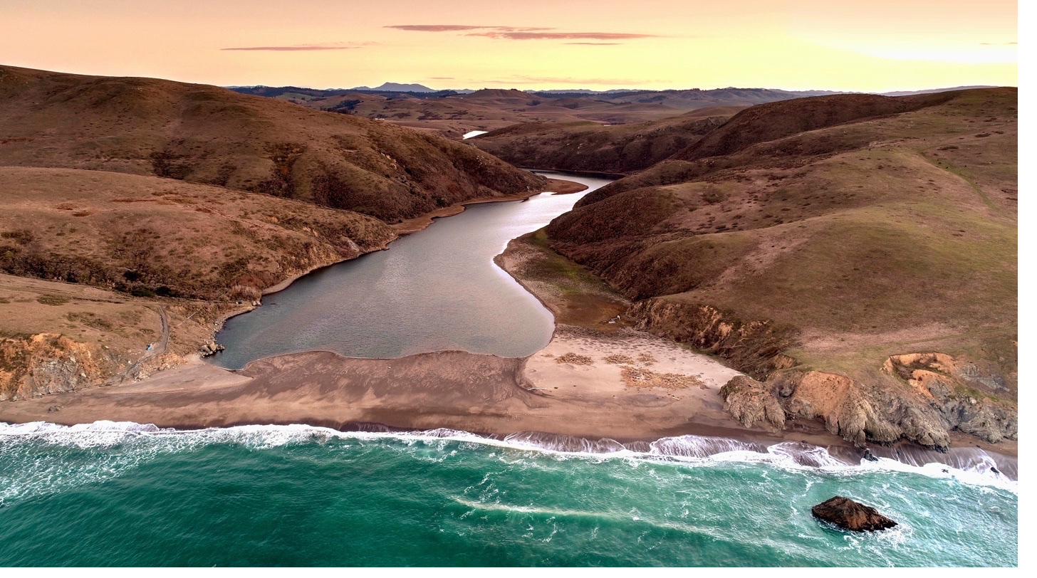
02 — On-Site OptionsOptions for the County to Evaluate — Revisited with Fresh Eyes

Every stakeholder conversation pointed in the same direction: preserve-site parking infrastructure is the key to making the preserve work for everyone. The question isn’t whether preserve-site parking is needed — it’s where and how.

The Association’s Position

The county must evaluate preserve-site options, then select and implement one.

What follows are options we’re bringing to the table for joint evaluation — with full recognition that some or all of these concepts may have been explored before, and that the Wildlands Conservancy, the county, and other partners may have done significant prior work in this territory. We aren’t claiming authorship of these ideas. We’re asking that we look at them together with fresh eyes, informed by what we’ve all learned since the preserve opened. If prior analysis exists on any of these, we want to build on it — not relitigate it. Each option has real benefits and real drawbacks. We should evaluate them collectively and choose the one that works best for everyone.

The options fall into two primary categories based on how visitors reach the preserve: some involve roadway access (a new or improved road leading to a parking area near the Estero), and some involve hiking access (parking at an upland location with trail connection to the preserve). A third category explores shuttle / transit service as a demand management layer. Each approach has distinct trade-offs in cost, permitting complexity, ecological impact, and visitor experience — and prior thinking on any of these fronts is welcome at the table.

Map Legend: Parking Area Roadway Access Trail Connection
Note: All maps shown are thematic indicators only and do not represent actual topographic routes. Any access path or road would require formal survey, engineering, and permitting.
🛣️
Options 1–3 — Roadway Access
New or Improved Road to Estero-Adjacent Parking
Aerial map showing Osprey Roadway option with parking near the Estero accessed via a new road from the south
Option 1
Osprey Roadway
ParkingNear Estero
AccessNew road from south
Crosses BHHARoadway only
Residential ImpactBypasses streets
Aerial map showing Mockingbird Roadway option with parking near the Estero accessed via a new road from the mid-section
Option 2
Mockingbird Roadway
ParkingNear Estero
AccessNew road from mid-section
Crosses BHHARoadway only
Residential ImpactBypasses streets
Aerial map showing Pinnacle Roadway option with parking near the Estero accessed via a new road from the Pinnacle area
Option 3
Pinnacle Roadway
ParkingNear Estero
AccessNew road from west
Crosses BHHARoadway only
Residential ImpactBypasses streets
🥾
Options 4–6 — Hiking Access
Upland Parking with Trail Connection to the Preserve
Aerial map showing Osprey Hiking option with parking at the south BHHA boundary and a short trail to the Estero
Option 4
Osprey Hiking
ParkingSouth BHHA boundary
AccessShort trail to Estero
Road ConstructionMinimal
Residential ImpactBypasses streets
Aerial map showing Pinnacle Hiking option with parking near Pinnacle Gulch area and a trail connection east to the Estero
Option 5
Pinnacle Hiking
ParkingNear Pinnacle Gulch
AccessTrail east to Estero
Road ConstructionNone — existing infra
Residential ImpactBypasses streets
Aerial map showing Bruhn Ranch Hiking option with parking at the north near the ranch boundary and a long trail south to the Estero
Option 6
Bruhn Ranch Hiking
ParkingNorth — ranch boundary
AccessLong trail south to Estero
Road ConstructionShort connector
Residential ImpactBypasses streets
🚌
Option 7 — Shuttle / Transit
Regional Parks Shuttle Service from Remote Staging
Conceptual Model — Shuttle / Transit

A dedicated shuttle service from a remote staging area to the preserve trailhead — modeled on the proven Russian River shuttle program already operating in this region.

The Russian River shuttle demonstrated that a well-run, seasonal transit service can dramatically reduce road congestion, improve the visitor experience, and protect residential neighborhoods — all while keeping public access genuinely open. That model is a natural candidate for adaptation here. A shuttle from a county-managed staging area on SR-1 would eliminate preserve-related parking on Osprey Drive entirely, require no new road construction, and scale with demand. Detailed route mapping and staging logistics are subject to agency coordination with Caltrans, CHP, Sonoma County Regional Parks, and the County Department of Transportation.

Option 7
Regional Parks Shuttle
StagingPotentially repurpose county land on SR-1
ModelRussian River shuttle program
Road ConstructionNone required
Residential ImpactEliminates street parking
🚦
Agency coordination required for all options. For any of these solutions to be implemented safely and effectively, coordination with the appropriate agencies will be essential — including Caltrans, CHP, Sonoma County Fire, local emergency services, and the County Department of Transportation. Traffic volume planning for the preserve must be integrated with other planned projects and existing traffic patterns in and around Bodega Bay. No option can be finalized without this multi-agency alignment step.
⚖️
The Association is not endorsing a preferred option. Each of these seven approaches has benefits and drawbacks that need to be weighed by all stakeholders together. We present them as a starting point for joint evaluation — not a conclusion. We want to hear from TWC, the county, emergency services, the Coastal Commission, and the public before narrowing the field.
What All Seven Options Share

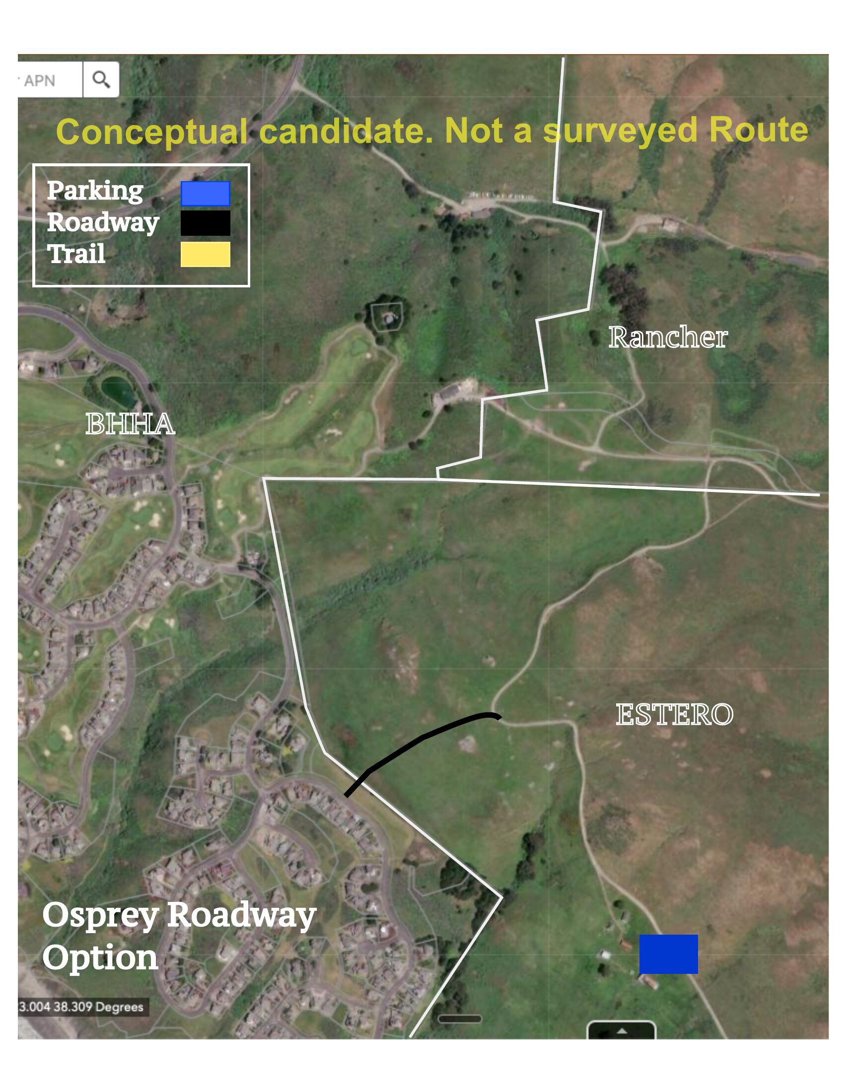
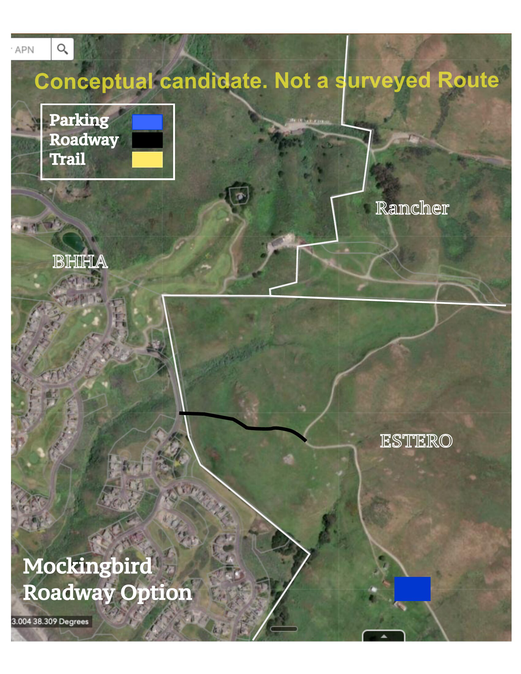
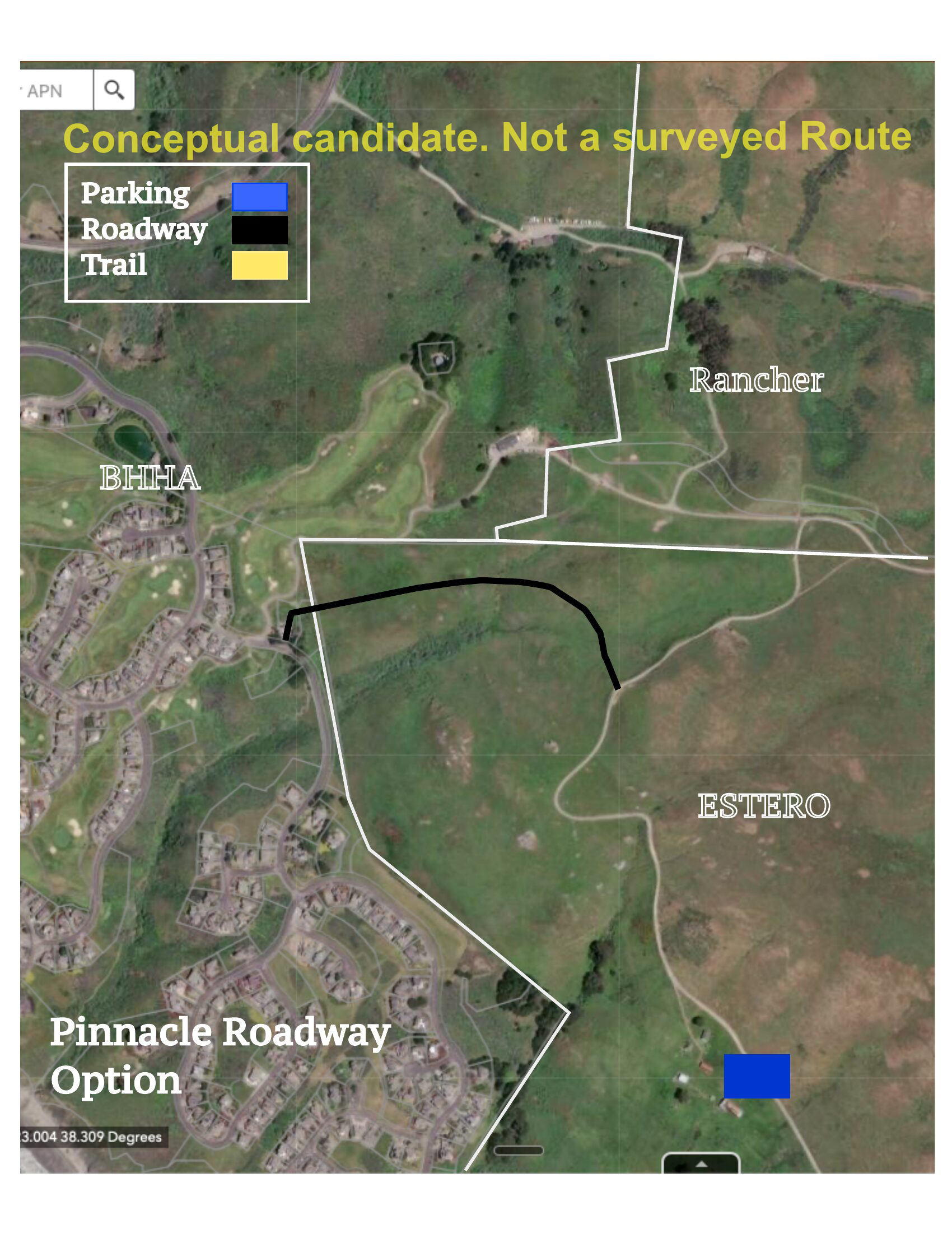
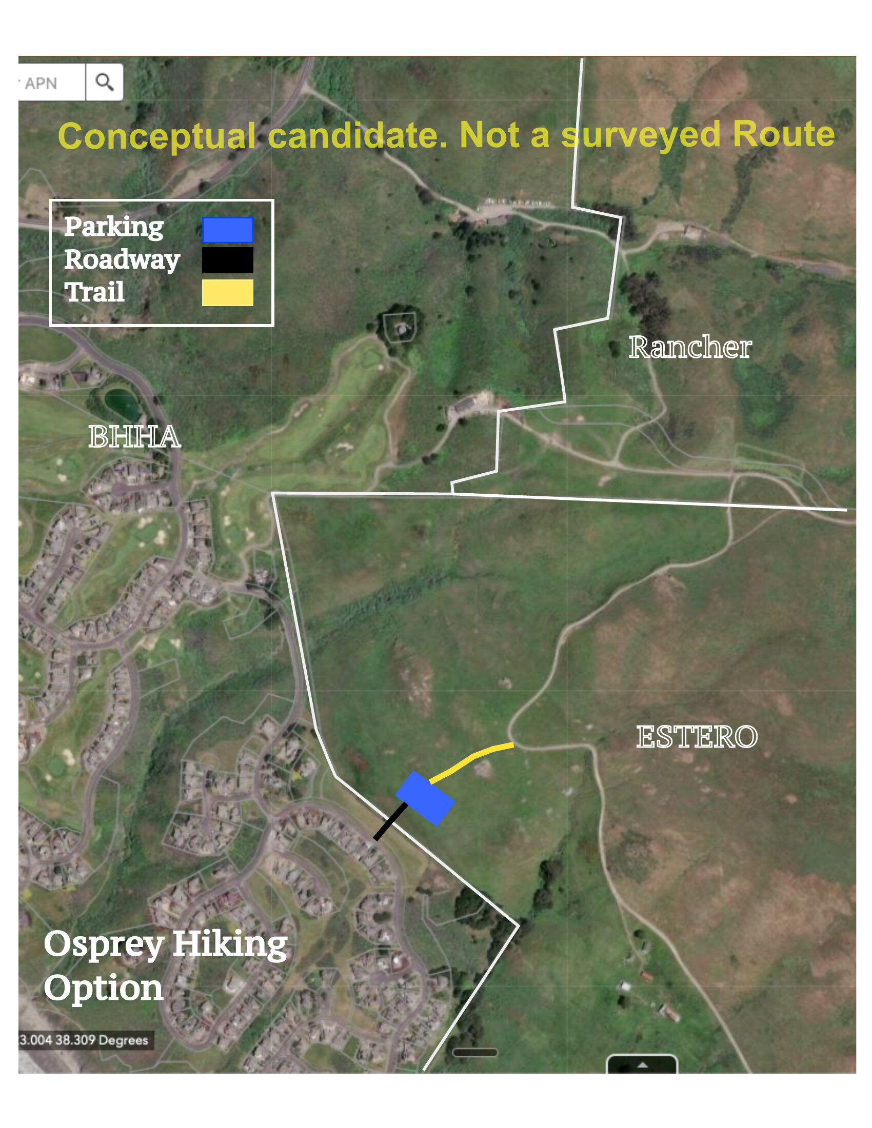
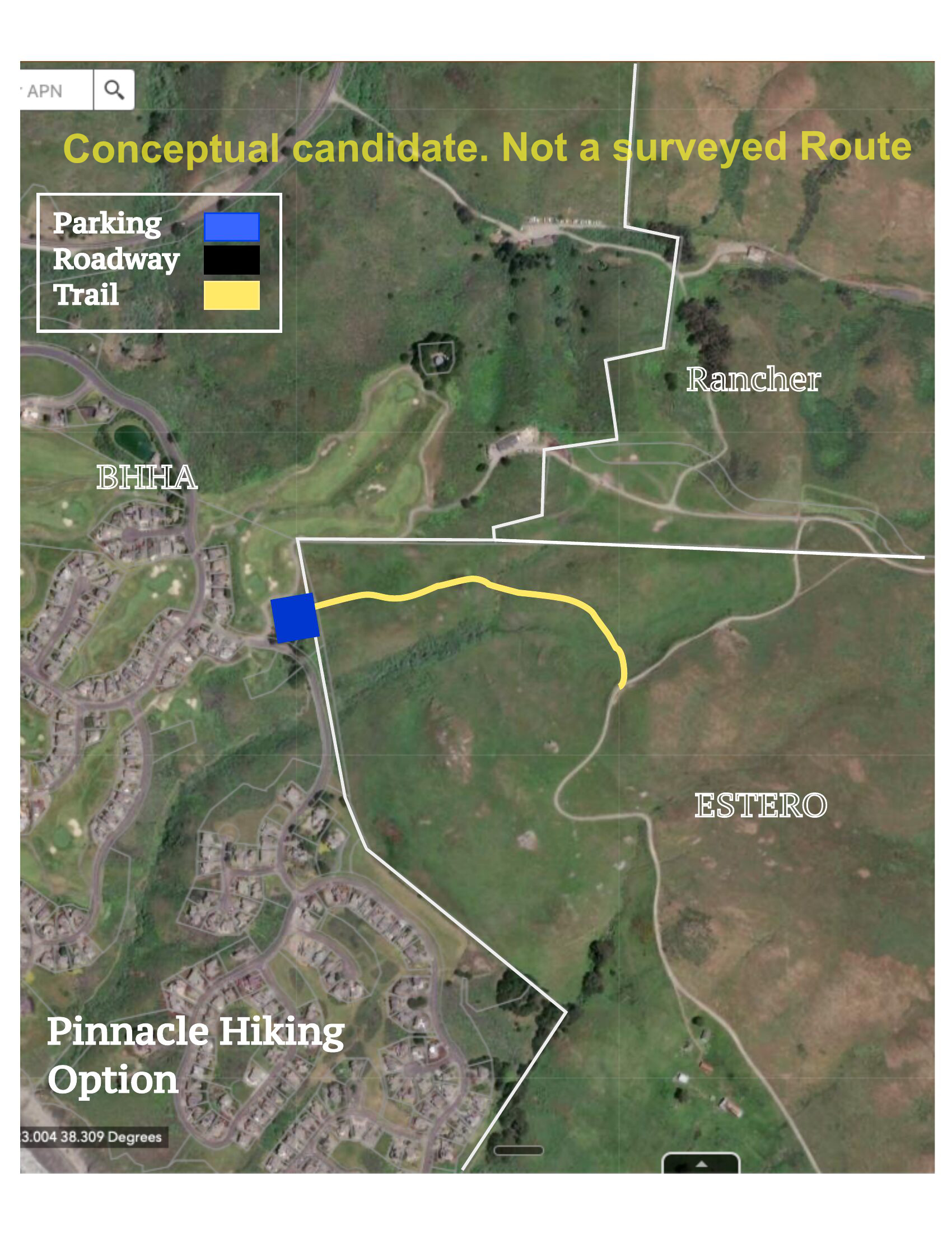
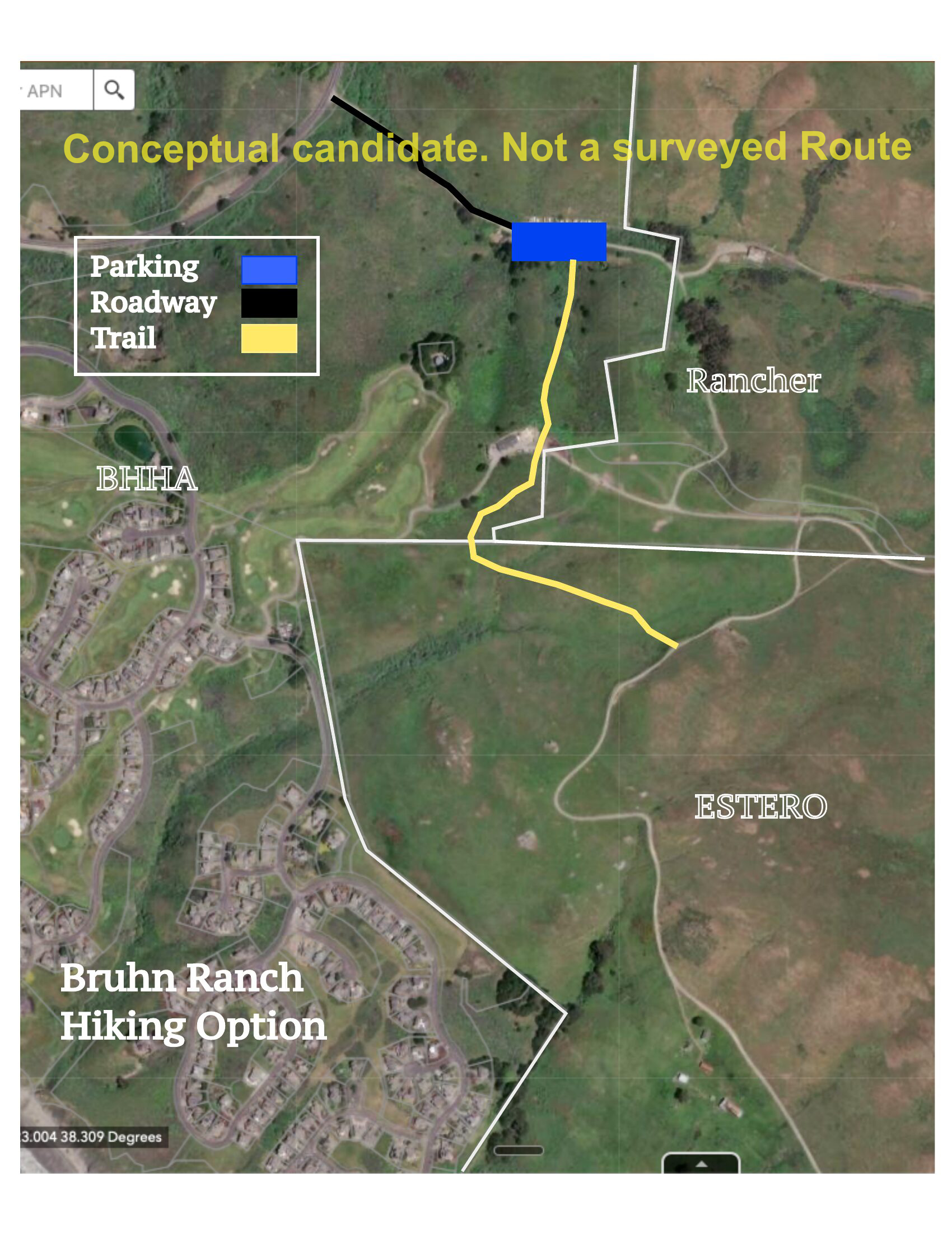
Every option addresses the core problem the same way: move visitor parking off residential streets and onto purpose-built preserve-site infrastructure.

Regardless of which option is ultimately selected, the underlying logic is the same. Visitors get a designated destination with clear wayfinding. Emergency services get unobstructed road access. The county gets an enforceable framework. TWC gets sustainable public access. The Coastal Commission gets enhanced — not diminished — public access to the coast. And the visiting public gets a welcome experience instead of an adversarial one.

🅿️
Surface
Low-Impact Surface
Determined by appropriate balance of ecological care and visitor access
🚗
Capacity Target
60–80+ Spaces
Sized to peak-day demand; scalable by phase
📍
Location
Off Residential Streets
All options bypass Osprey Drive and neighborhood roads
🚌
Future Integration
Shuttle-Ready
Designed to accommodate staging for overflow shuttle service
🌿
Environmental
Sensitive Habitat Aware
Located to minimize sensitive habitat disturbance
🔍
Evaluation
Joint Stakeholder Review
Benefits and drawbacks assessed collaboratively before selection

03 — Needs, MappedHow On-Site Parking Addresses Every Stakeholder Need

Regardless of which option is ultimately selected, preserve-site parking infrastructure addresses every stakeholder need we’ve identified. Each row reflects the position described in Section 01 — confirmed or inferred — and how moving visitor parking off residential streets resolves it.

Stakeholder What We Understand You Need How On-Site Parking Meets It Status
The Wildlands
Conservancy
Preserve stays open; access isn’t shut down by community opposition or regulatory pressure Dedicated parking gives the preserve the infrastructure its success deserves. With visitors welcomed at a proper trailhead, the preserve can be open sustainably — exactly what TWC worked a decade to achieve. ✓ Fully Met
BHHA Residents Emergency vehicle access maintained; visitors welcomed at a proper trailhead rather than dispersed through residential streets Visitors have a designated destination. Parking ordinance has teeth because there’s somewhere legal to send people. Osprey Drive becomes a residential street again. ✓ Fully Met
Supervisor Hopkins
& County
A durable, enforceable solution — not a patch that shifts the problem The parking ordinance works when paired with a legal alternative. Without the lot, the ordinance displaces parking to adjacent streets. With it, enforcement has a destination to point to. ✓ Fully Met
CHP & Fire
Services
20 ft unobstructed emergency access on Osprey Drive at all times, including peak days When visitors have a designated lot, Osprey Drive maintains the unobstructed clearance emergency services require. The infrastructure solution solves the safety equation completely — no ordinances, no enforcement gaps. ✓ Fully Met
California Coastal
Commission
Coastal access covenant honored; public access meaningfully available, not nominal Dedicated parking infrastructure makes public access more meaningful, not less. A well-designed trailhead welcomes the public and fulfills the spirit of the Coastal Act — not just the letter. Coastal access is genuinely enhanced. ✓ Fully Met
Ag + Open Space
(Easement Holder)
“Some level of recreational use available forever” per conservation easement Dedicated parking stabilizes and supports long-term public access. The recreation covenant is honored through infrastructure, not by accident. ✓ Fully Met
Regional Parks
(County)
Managed visitor flow; ability to direct people to nearby alternatives when capacity reached A capacity-defined lot creates a clear trigger point. When the lot is full, wayfinding and messaging redirects to Doran, Chanslor, Jenner. Managed demand becomes possible. ✓ Fully Met
Visiting Public Somewhere legitimate to park; a welcome experience; clear information A dedicated lot with signage, accessible spaces, and clear wayfinding transforms the visitor experience from adversarial to hospitable. They want to do the right thing — give them the option. ✓ Fully Met
California Coastal
Conservancy
Funded original acquisition; holds an Offer to Dedicate (OTD) on title — a conservation easement equivalent ensuring the land’s purpose endures Dedicated parking infrastructure stabilizes the public access mission the Conservancy invested in. A well-managed trailhead is the preserve succeeding on its own terms — exactly what an OTD is meant to protect. ✓ Fully Met
Ecological
Conservation
High visitation doesn’t degrade the habitat the preserve was created to protect Concentrated, managed access from a designed trailhead is less ecologically disruptive than dispersed, ad hoc parking and informal trail entry. Management capacity enables monitoring. ~ Partially Met

04 — We’re InBHHA’s Commitments as a Member of the Team

These are the specific ways BHHA commits to showing up as a reliable, accountable member of whatever team emerges from this conversation.

01
BHHA Board
Active Participation in Joint Governance
BHHA’s primary responsibility is to protect the interests of our homeowners — that’s foundational. We also believe that protecting those interests, in this situation, means being a committed and good-faith participant in the collaborative process that follows. We will participate in a formal multi-party working group with TWC, the county, Coastal Commission, and emergency services. We will show up, do the work, consider the full range of options with an open mind, and hold ourselves accountable to shared decisions.
02
BHHA Board
Support for Joint Option Evaluation
We will actively support a rigorous, collaborative evaluation of preserve-site parking options — contributing our local knowledge and resources while deferring to the collective judgment of the stakeholder group on which option best serves all parties. We commit to working in parallel to ensure visitors have a welcoming, clearly-signed destination regardless of which option is selected.
03
BHHA & Jeff Burke
Shared Awareness
We will support the development of a public-facing resource that keeps the shared picture visible between meetings — current status, key milestones, and the map this community has already drawn together. Shared awareness is the foundation of shared action.
04
BHHA Community — For Discussion
A Neighbor Welcome Presence — Topic to Explore Together
One idea worth exploring: BHHA residents serving as welcoming faces on peak days — helping visitors find parking, sharing trail information, and embodying the spirit of a community that is genuinely glad the public is here. We raise this as a topic for the group’s consideration, not a commitment already made. If it sounds useful, we’re interested in designing it together.
Our Ask — and Our Offer

We are asking the county to formally evaluate preserve-site parking options for the Estero Americano Coast Preserve. We’ve proposed seven to start the conversation. We hope the assembled parties will build on what’s here, correct what we’ve gotten wrong, and help us jointly select and implement the option that best serves every stakeholder.  We are ready to do this work — together.

Our Offer to All Parties

We all painted this. Now let’s build it together.

The Wildlands Conservancy added their stroke: a decade of conservation work and a genuine commitment to public access. The county added theirs: operational knowledge and regulatory tools. Emergency services added theirs: technical precision no one else had. The Coastal Commission added theirs: the legal framework that anchors the whole picture. Neighbors added theirs: specific local knowledge and real, named solutions. BHHA added ours: 50 years of living alongside this land, and a deep desire to see it succeed. Together, these strokes resolve into a picture that we hope feels familiar to everyone who helped paint it. If it does — let’s build it.

Every voice in this conversation left something real on these pages. We’ve done our best to honor all of it — and to add our own perspective as neighbors who love this coast and want this preserve to thrive for generations. Seven options are on the table. We’re not asking anyone to accept our answer — we’re asking everyone to help choose the right one. Together.